Introduction
Building on our Ultimate Guide to Crop Monitoring in Precision Agriculture (Read Here), this article explores how to implement and maximize crop monitoring using ESS. With AI-powered satellite insights, ESS enables real-time decision-making, from field digitization to variable rate applications (VRA).
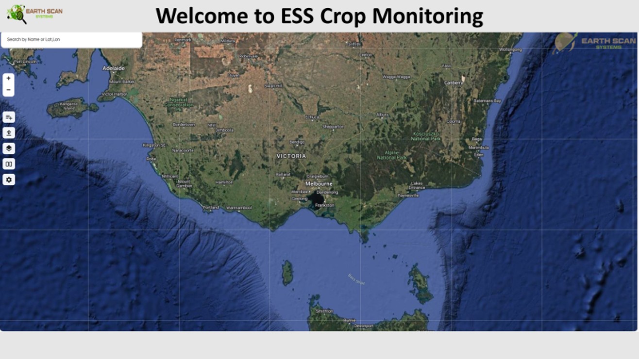
Dashboard Overview
Once logged in, you’ll have access to:
- Geolocation Tools – Locate your field by address or coordinates.
- Field Uploads – Upload a KML file or manually draw field boundaries.
- Crop Selection – Define your crop type and sowing date.
- Historical Data – Analyze past crop performance.
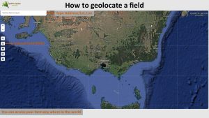
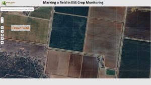
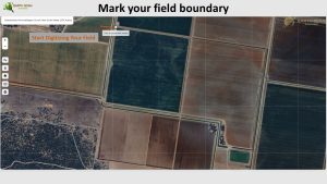
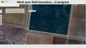
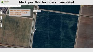
2. Marking & Digitizing Your Field
In our Ultimate Guide, we introduced the best times to use vegetation indices for crop health analysis. Now, with ESS, you can:
- Mark field boundaries using Geo-location tools.
- Digitize the field by drawing a polygon over your land.
- Save & Store your field for real-time monitoring.
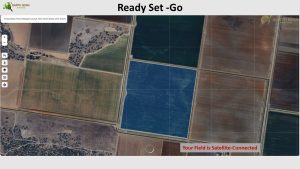
- Connect to Satellites for continuous crop analysis
.
3. Real-Time Crop Monitoring
ESS enhances the application of vegetation indices (NDVI, MSAVI, NDRE, ReCI, NDMI) by automating their analysis at key growth stages.
Key Monitoring Features:
🌱 Vegetation Health – Automated NDVI tracking for crop growth stages. 💧 Soil Moisture – Identify drought stress and irrigation needs. 🌾 Nitrogen Levels – Optimize fertilizer application using NDRE. 📈 Variable Rate Application (VRA) – Generate precision farming maps based on satellite indices.
By aligning these insights with the Ultimate Guide, farmers can time their interventions precisely for maximum impact.
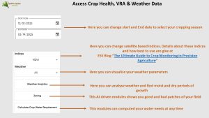
4. AI-Powered Insights & Weather Analytics
ESS combines AI-driven analytics and weather forecasting to enhance decision-making:
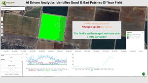
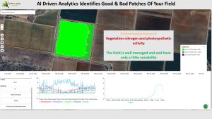
- Compare Vegetation Health Over Time – Use past NDVI and MSAVI trends to detect changes.
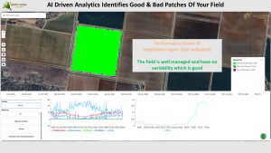
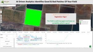
- Performance Zones – Identify strong and weak crop zones based on index variability.


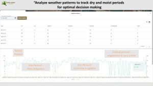
- Weather Forecasting – Access real-time temperature, precipitation, and humidity data.
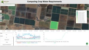
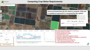
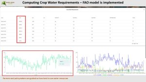
- Crop Water Requirements – Compute water needs using the FAO model, complementing NDMI-based moisture assessments.
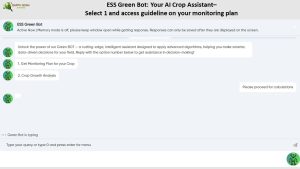
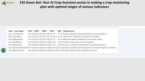
5. ESS Green Bot: Your AI Crop Assistant
The ESS Green Bot guides users in choosing the right vegetation indices at different crop stages (as covered in the Ultimate Guide). This AI assistant provides: ✔ Alerts for stress detection based on satellite readings. ✔ Recommended irrigation and fertilization schedules. ✔ Smart analytics for disease and pest control.
6. Decision-Making with AI-Driven Comparisons
ESS allows farmers to compare vegetation indices dynamically:
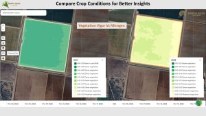
- Vegetation Vigor vs. Nitrogen – Assess fertilizer impact using NDRE.
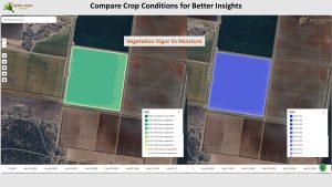
- Moisture Levels vs. Growth – Optimize irrigation using NDMI.
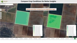
- Before & After Analysis – Visualize crop changes using ReCI and NDVI.
- Performance Zones Mapping – Identify high-yield vs. weak zones.

-


This ensures farmers make data-backed decisions to improve efficiency and maximize yields.
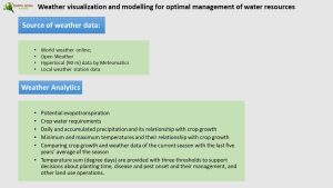
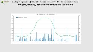
7. Weather Analytics for Smart Farming
ESS integrates agro-meteorological data to support climate-adaptive farming decisions. This builds on the Ultimate Guide’s approach by offering AI-powered weather monitoring.
📊 Key Weather Features:
- Evapotranspiration Modeling – Assess water loss from crops.
- Historical Weather Trends – Compare current season with 5-year data.
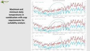
- Temperature Sum (Degree Days) – Predict pest & disease outbreaks.
- Irrigation Planning – Detect critical dry periods for optimized watering
.
Why Choose ESS Crop Monitoring System?
- 5-Day Monitoring Cycles – Continuous tracking from sowing to harvest.
- Satellite-Connected Fields – AI-powered insights on vegetation indices.
- Global Access – Monitor crops anywhere in the world.
- AI-Driven Insights – Smart decision-making for optimized yields.
By combining the Ultimate Guide’s best practices with ESS automation, farmers can increase efficiency, cut costs, and maximize productivity.
🌟 Get Started Today!
📩 Contact us for a demo: contact@escan-systems.com
Elevate your precision agriculture strategy with ESS


